Since its inception, RIMES has been developing and integrating tools with national and regional systems for advisory generation which are customized based on countries' evolving needs.
Ocean state forecasting and advisory system:
Web-based system for generation of advisories based on location-specific ocean state forecast information from INCOIS’ Indian Ocean Forecast System (INDOFOS).
The system disseminates 3-day forecasts of wave and swell height, direction, and period, sea surface current and temperature, and wind speed, with accompanying advisories, displays real-/ near real-time observation data and receives user feedback for validating forecast information. The system also provides marine fishery advisories and coral reef mapping and health monitoring information. In addition, the system has capability to track wave rider buoy location and has an alert messaging service in case of buoy drift.
ShakeCast:
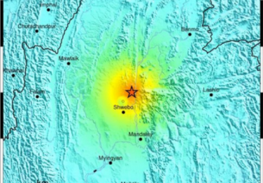
Online tool for rapid earthquake risk assessment
RIMES customizes ShakeCast, a tool developed by the U.S. Geological Survey for estimating risks to population and critical facilities using real-/ near real-time data from an earthquake event. Potential damage information is sent to registered users by SMS, fax, and email.
Bulletins are updated based on improved earthquake parameters for the event. ShakeCast customization uses exposure data at the smallest administrative unit (e.g. village level population data and detailed building inventory) and appropriate building vulnerability functions.
INSPIRE:
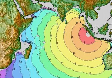
Online tool for tsunami propagation and inundation simulation and risk assessment
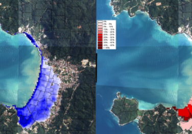
RIMES’ internet-based simulation platform for tsunami inundation and risk evaluation, named INSPIRE, is a web portal that provides modules for: identifying tsunami sources, simulating tsunami propagation and inundation, integrating exposure data, and performing tsunami loss estimation. The analysis modules are designed to handle multi- dimensional vulnerability data and different levels of data accuracy, allowing users to undertake preliminary tsunami risk assessment using available data, with progressive improvement in assessment results as more detailed and accurate datasets are used. INSPIRE outputs include tsunami inundation maps, showing maximum inundation depths, maximum flow velocities, and estimated tsunami arrival times; and tsunami loss estimates in terms of probability of casualty, probabilities of building collapse/ severe damage for different building types, and number of buildings that could be inundated at an inundation depth range for buildings of different construction and occupancy types.
PRECISE:
Web-based portal with near real-time tsunami forecasting system for regional estimation of coastal tsunami impacts using earthquake and tsunami information.
The system retrieves tsunamigenic earthquake information within the RIMES area of responsibility from the seismic data acquisition system and calculates slip values of selected unit sources based on earthquake magnitude, retrieves sea level data from the sea level data acquisition system
systematically combines tsunami simulation results from a pre-computed tsunami simulation database, for all unit sources that contribute to the earthquake using a superposition method; refines unit source parameters based on sea level data using inverse analysis technique, computes inundation using bathymetric and topographic data, in three nested regions; visualises tsunami amplitude, arrival time, and coastal inundation in Google Earth and generates tsunami bulletin